Earth, a virtual journey into the world and in time
Google Earth is an affordable online service with software for installation on a computer that offers a virtual 3D representation of 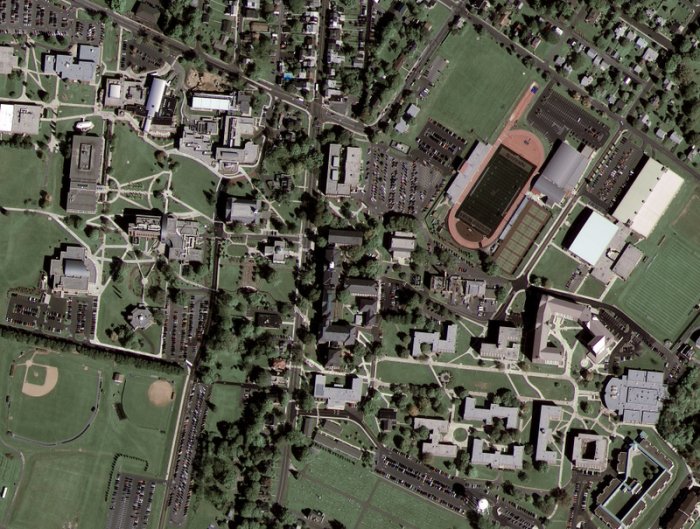 the World.
The images are taken by GeoEye, a satellite half-funded by the National Geospatial Intelligence Agency (NGA) and Google and other sponsors (all for $500 million), which offers the thinnest resolution ever achieved for aerial imagery. It provides images on its "Earth" service. Although the NGA is an agency that serves US security, it is not a spy satellite, in contrast, the pictures it takes are intended for the public via an internet channel.
The definition allows you to achieve accuracy in details of 43 cm. Note that American laws prohibit the publication of images with an accuracy of more than 50 cm, so it is the latter that is the level of detail of the photo on the right. This is the first picture taken by GeoEye-1, and this is a photo of Kutztown University in Pennsylvania.
Internet users are also invited to contribute to the project by offering 3D building models. By combining these models with StreetView images, you can visit cities virtually.
At the end of January 2015, Google Earth pro, which offers such specialists tools as high viewing resolution, accurate measurements of land and real estate, became available to everyone for free.
Ancient Rome in virtual reality
Google Earth no longer invites you to travel in 3 dimensions, but still adds time travel. Indeed, you can now visit Ancient Rome in 3D thanks to Earth.
To access the fourth dimension, enter Ancient Rome in 3D in the Gallery folder. But first, download the latest version of Google Earth...
Paleontology
After discovering a forest of a different age in Africa, the Earth made it possible to make an archaeological find: a very rare hominid in South Africa.
From satellite imagery reproduced on Earth, researchers can identify sites that contribute to archaeological exploration and focus their efforts on those sites.
Seabed
3D-vision of oceanographic funds is offered, which allows you to explore pits up to 11 thousand meters (the deepest is the Mariana section).
You can track the movement of marine fauna, but Google avoids providing information that fishermen (such as whales) can use.
Google has teamed up with several marine-related sites to provide related information to internet users.
Video: Explore the oceans.
History of the place
The historical function from version 5 allows you to track the evolution in time of a geographical place: the construction of a building, a melting glacier, the advancement of desertification in Africa...
Disneyland
Google has built in a virtual walk through Disneyland Paris thanks to Google Earth.
And to get an overview of the walk, a demo video was posted on Youtube.
To achieve this result, it was necessary to integrate 85 thousand photos with Earth, from which textures were made for 3D vision.
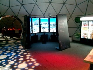
Liquid Galaxy, World in Virtual Reality
To immerse itself in the virtual world, Google has developed Liquid Galaxy (image right) - a set of screens for displaying the World through the Earth.
The video is impressive...
The system has been installed in many establishments around the world, and if you feel capable, you can complete your own installation!
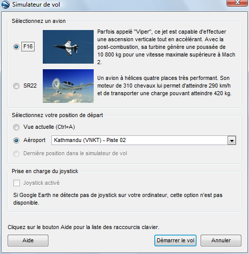
Flight simulator
Starting with version 4.2 of the "Earth" software, it is possible to switch to flight simulator mode, as well as perform transitions over relief maps.
To enter flight mode, press CTRL + G for both keys pressed at the same tempo.
To return to board mode, we set CTR + T.
To speed up, press the right mouse button and move it back to slow down.
The left button is also combined with mouse movement to tilt the plane one way or the other or turn...
To select the aircraft and the airport, press CTRL + ALT + A keys at the same time, at that the aircraft selection window opens:
Driving simulator
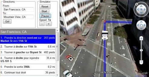
After the flight simulator, here's a driving simulator, in tourist optics, not auto racing, watch the scenery as your car moves through the streets of the city you'd like to visit, or in the countryside or the mountains.
For the simulator to work, you need, if not already done, to load the Earth API. But this is automatic when you go to the demo page, if the API is not found on the computer, the site offers to download it, then you need to click on the received executable file.
To use the simulator, select a starting point and an arrival point, for example, two neighboring cities. The system loads the data and you can press the "start..." button to start the trip.
So the software works like a route computing site (Michelin, Mappy...) to which Earth adds the ability to see the scenery we're about to visit!
The accelerator has the shape of a + button, which can be pressed with the mouse .
There is nothing from Porsche or Ferrari in the car, but it is the landscapes that are interesting ...
Google Earth Ship Simulator
It is an online game based on Earth. Indeed, Google provides an API that allows online software to interact with a virtual representation of its proposed real world.
The program uses Flash, JavaScript, Sound Manager 2 and Sketchup to create 3D models.
It only lacks a collision detector.
The Dutch company had a dubious idea to use the Street View API to create a game like Doom: the goal is to shoot passers-by from all cities in the world. The app was a big hit - thousands of visitors a minute before Google pulled the plug. In addition to immorality, it blew up servers. It lasted only four days.
Building Maker: adding buildings
This tool was offered until June 1, 2013, and was an online modeling tool for Earth, compatible with Sketchup. Netizens could add buildings with their signature to the map. An example of this was the Forbidden City, which was restored using 3D printers, so it combined many technologies!
"Earth" provides only photographs of buildings that are registered from the satellite. To go further, the user points to a place on the map where he would like to add a building that is really visible in 3D, that is, from all sides.
The online software then provides him with photos of the building taken from different angles and a toolbox for intuitive use. It also displays a 3D cube. It remains for the user, with tools provides, to model the building based on photographs.
Under the name "Model Your Town Competition," Google offered to model their city using Google Building Maker and SketchUp.
See also
More videos
- Earth in 3D. The new technology allows you to build a 3D view of cities.
- Google Earth 5.0.
- Strange aerial views discovered by Earth.
- New York in 3D.
For developers